Valsugana is a valley in eastern Trentino that opens between the Altopiano dei Sette Comuni and the Lagorai chain, running for some eighty kilometres from Lake Caldonazzo down to the Veneto border at Primolano. It is one of the broadest and most densely populated valleys in the province of Trento, traversed by the river Brenta, the historic Valsugana railway and the SS47 trunk road that connects it to Bassano del Grappa and the Venetian plain. This site was set up as an independent guide to the valley: an editorial collection of pages on destinations, lakes, routes and history, written for travellers planning a trip without the commercial pressure of the booking portals.
Valsugana is a mid-altitude mountain destination, Italian in dialect and Catholic in calendar, that built itself a clear tourist identity in the 1980s around three pillars: the swimmable lakes of the upper valley, the historic spas of Levico and Roncegno, and the cycle path that runs the whole length of the valley with barely any gradient. Around this core have grown the hiking trails of the Lagorai to the south and the Vigolana plateau to the west, the food and wine culture of Trentino, and one of the densest networks of mountain huts and alpine pastures in the eastern Alps.
What sets Valsugana apart from the other Trentino valleys
The first difference is linguistic. Unlike Val di Fassa or Val Gardena, neither Ladin nor German is spoken here: Valsugana is an entirely Italian-speaking valley, with Venetian dialect traditions in the lower stretch and Trentino dialect in the upper. This shows in place names, in the cooking, in the way the twentieth century is remembered. You sense the linguistic frontier the moment you arrive from Trento or Bolzano: names turn Italian, and restaurants serve polenta and tortellini rather than canederli and spätzle.
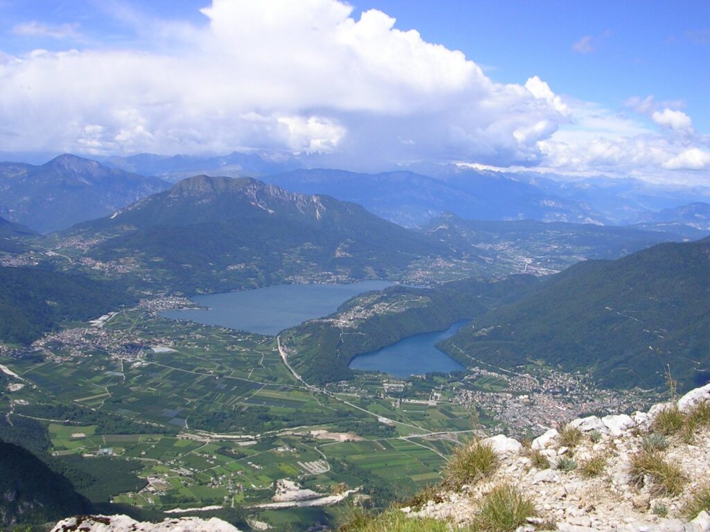
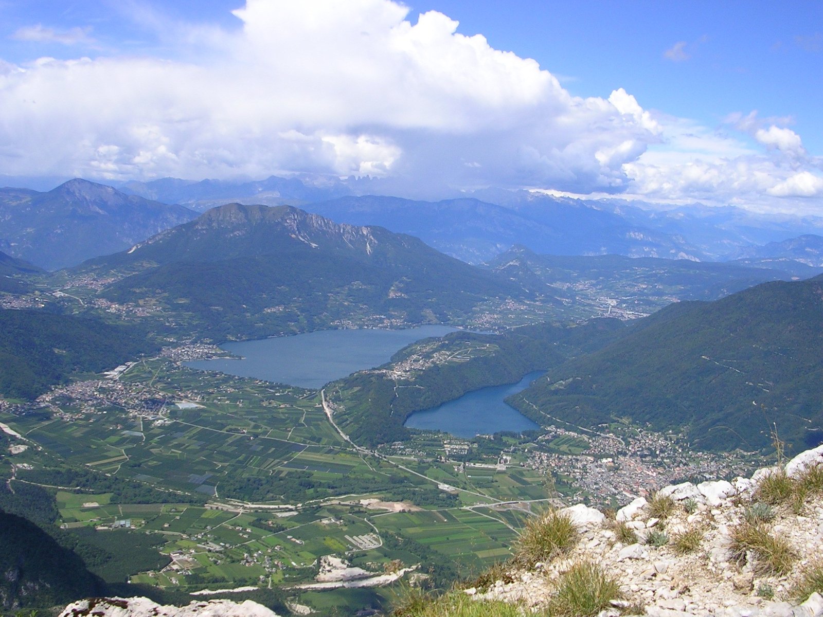
The second difference is the presence of the lakes. Lake Caldonazzo is the largest natural lake lying entirely within Trentino territory and reaches summer water temperatures of around 24 degrees: a rare figure at alpine elevations, which has made it for decades a swimming destination for Venetians and Lombards looking for a cool alternative to the sea. Lake Levico is smaller and deeper, hemmed in between the wooded slopes of Tenna and Cimone, and has kept a more reserved atmosphere. Together the two stretches of water define the character of the valley floor.
The third difference is the thermal dimension. Levico Terme and Vetriolo still operate a spa that has been active since the late nineteenth century, with iron- and arsenic-bearing oligomineral waters drawn from high-altitude springs. Across the turn of the twentieth century it was one of the favourite spa destinations of the Central European aristocracy under the Habsburgs, and later of the Italian elite; today it retains a historic spa park and a facility that operates under both medical and wellness regimes.
The three landscapes of Valsugana
The upper valley of the lakes
The Alta Valsugana, roughly between Pergine and Levico, is the most open section of the valley. The valley floor widens here into a glacial plain that holds the two lakes and a string of small but lively villages: Caldonazzo, Calceranica al Lago, Pergine Valsugana, Tenna, Levico Terme. This is the area of greatest summer tourist activity, with lakeside lidos, campsites, walking and cycling paths along the shores, a good density of restaurants and rental flats. Elevations are low, between 450 and 500 metres, and the climate is that of a pre-alpine valley floor: hot summers tempered by the water, fresh winters with little settled snow on the plain.
The historic lower valley
From Roncegno downwards the valley narrows progressively, the Brenta cuts tighter gorges, and the villages take on a more rural and less tourism-driven character. Borgo Valsugana, Strigno, Castel Ivano and Grigno are ancient settlements, with stone and timber architecture, castles that recall the long-standing frontier between the Habsburg empire and the Republic of Venice, and a peasant way of life that has been preserved even after the arrival of the SS47. This is the part of the valley where the traces of the First World War are still very legible in the landscape. Read more on the history of the valley.
The mountains on either side
To the south rises the Lagorai chain, one of the longest and least built-up porphyry ridges in the Italian Alps: some seventy kilometres of crests, high-altitude tarns and mountain pastures, with trails that climb from Borgo, Roncegno and Strigno to elevations above 2,500 metres. To the north-west sits the Vigolana plateau, and to the east the Vezzena plateau that links Valsugana to the Sette Comuni in the province of Vicenza. These three mountain zones offer hiking of very different levels, from family-friendly strolls to multi-day traverses.
When to visit Valsugana
The natural high season runs from mid-June to mid-September, when the lakes are warm enough for swimming, the alpine huts are open and the Valsugana cycle path hits its peak of use. These are the months when the valley really lives its tourist identity: music in the spa parks, markets, sporting events on the lake, lunches on hut terraces. May and October are perfect transition months for travellers seeking calm and lower prices: the valley has already opened, but the pressure is lower and the colours of the woods make the routes more rewarding. Winter is more of a spa and cultural option than a sporting one: the elevation of the valley floor does not guarantee a steady cover of snow, and the ski resorts are some distance away.
How this site is organised
We publish guides to the main themes of the valley, written with the eye of an informed traveller, not a promoter. Each page sets out to answer a concrete question: how to plan a holiday, where to swim, what Levico Terme offers beyond its waters, what it is really like to ride the eighty kilometres of the cycle path, what the essential facts of the valley’s history are. We do not run bookings and we do not take fees from the accommodations we mention: for sleeping, eating or arranging transfers we send readers directly to the websites of the properties involved or to the official tourist boards.
- Valsugana holidays — the complete 2026 guide on when to go, where to stay, and how to get around.
- The Valsugana lakes — Caldonazzo and Levico, swimming, lidos, lakeside trails.
- Levico Terme — the historic spa town and its territory.
- The Valsugana cycle path — eighty kilometres from Trento to Bassano del Grappa.
- The history of the valley — Habsburg frontier, the Great War, the post-war years.
- About us — our editorial stance and why we are an independent guide.
The pages are updated periodically on the basis of public data from the local tourist boards, councils and operators. Where a source is uncertain or a figure cannot be verified, we say so explicitly. Our ambition is not encyclopaedic completeness but a guide that reads well and saves the reader time when they are still in the planning phase.